
In summer, Georgia should go not only for Khinkali tasting, a beach vacation and a visit to Tbilisi. While the cities are melting from the heat, it’s time to go for a walk among ice lakes and mountain peaks. They collected a selection of popular simple routes in different parts of the country. You can go to the light tracking yourself, and for medium complexity routes you will need a guide.
For entry, Russians will need only a passport, without a visa in the country you can be 365 days. PCR tests and vaccination certificates will also not be needed-on June 15, the country canceled all restrictions. From Russia to Georgia, you can get through the Upper Lars checkpoint if you are ready for a rather tedious long road. It is more convenient to fly by plane to Tbilisi or Kutaisi, but you will have to make a transplant, for example, in Minsk.
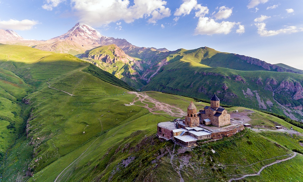
The Church of the Holy Trinity
Complexity: Light
You probably saw this “open” location in the photographs: a small church huddles high in the mountains, and behind it, among the re vasy of clouds, then a magnificent Kazbek appears, then hides. Perhaps this is one of the most striking Georgian attractions, for the sake of which you can overcome a fairly long path of 160 km from Tbilisi along the old road. To the nearest settlement – the village of Kazbegi – can be reached by minibus, it leaves from the Tbilisi bus station located near the Diduba metro station. To make the trip more comfortable and fast, we recommend that you take the car for rent.
The Church of the Holy Trinity in Gergeti is a place where the culture of the country and its natural beauties are connected. It is located at the foot of Mount Kazbek, in the Hevy gorge, at an altitude of 2 170 meters above the village of Kazbegi. Let these numbers not scare you, because the city itself is located at a mark of 1,744 meters. The path to the target runs through the village of Gergeti, the rise takes about two hours. We recommend that you admire the modest decoration of the temple and, if you are lucky, listen to the singing and prayers of the ministers.
At the temple, you can replenish the stocks of drinking water and take a walk in the vicinity – it seems that Kazbek is very close, so you can arrange a spectacular photo shoot against the background of mountains and alpine meadows. After a walk, it will be especially pleasant to eat Georgian cuisine dishes in one of the Kazbegi cafe.
Where to stop
The church looks completely in a special way at night, when the moon rises and floods the valley with light. The dome temple “nests” high at the peak and flashes with a bright spark against the background of the Kazbek snow -white cap. Therefore, we recommend that you linger in the Kazbegs in order to enjoy the views at different times of the day. Picked up hotels with good marks of visitors:
Cliff House (rating 10 out of 10) – from 3,750 rubles* per night in a double room;
Discover Kazbegi Hotel (rating 10 out of 10) – from 3,100 rubles* per night in a double room;
Sunny Mountain House (rating 9.7 out of 10) – from 2,000 rubles* per night in a double room.
Canyons Birtvisi
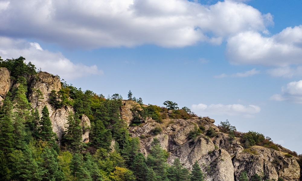
Complexity: Light
The route is suitable for those who do not want to leave far from Tbilisi or have not so much time in stock. The canyons are 80 km from the city, in the Kvemo Kartli region. First of all, you need to get by a car to the village of Partshisi and from there pass 2 km to the village of Tbisi. The village itself is located on the left side of the highway, and a pair of buildings and a trail with a pointer – to the right. The walking path to the canyons is 3.5 km, it needs to be laid on Hike for 3-4 hours.
Interestingly, the canyons are divided into “dry” and “wet”. “Dry” is a forest area, throughout which huge stone blocks rise. “Wet” are waterfalls and natural baths, which stretched at a distance of about 7 km. It is impossible to go through the whole “wet” canyon without special equipment and the help of instructors, so for starters we recommend a more familiar “dry route” to visit. You will find the mysterious atmosphere inherent in forest paths, the remains of the ancient defensive fortress of Birtvisi and views of bizarre mountain ranges opened with the plateau. The highest point of the canyons is located at an altitude of 1,200 meters above sea level, so stock up on nuts and snacks so that there is definitely enough strength to climb higher.
Not far from the location is the Alget reservoir. You can go there after an active tracking and arrange a picnic at cool water.
Where to stop
If you want to wander longer among the labyrinths of the canyons, you can spend the night in a tent on one of the picturesque hills. Or return to Tbilisi to take a walk around the evening city, drink a glass of Kinzmarauli and taste the khinkali. Here are a few options for hotels:
Kisi by Tbilisi Luxury Boutique Hotels (rating 9.5 out of 10) – from 6,859 rubles* per night in a double room;
Stamba Hotel (rating 9.4 out of 10) – from 23,400 rubles* per night in a double room;
Holidy inn Tbilisi (rating 9.1 out of 10) – from 8,850 rubles* per night in a double room.
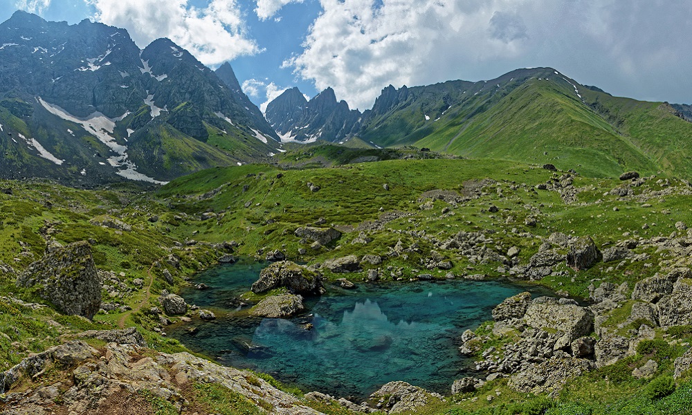
Abuladar lakes
Complexity: Light
The location is located at the foot of the passenger pass, on the southern slopes of the Tusheti-Hevsurat part of the East Caucasus Range at an altitude of 2,600-2,800 meters. The nearest settlement is the village of Roshka (Hevsureti), from it to Abulaury about 7 km.
It is most convenient to get to Roshka by car, the road will take about two hours. Not far from the village there is parking where you can leave the car. From here begins the path marked with white and blue towards the lakes. This is a fairly light route: the path is as if framed by steep slopes from all sides, so it is very difficult to turn the wrong way. The green valley with multi -colored flashlights of alpine flowers is visible far ahead. But the weather in the mountains is changeable, so you always need to be prepared for sudden fog or rain. Be sure to take with you a fleece sweatshirt, windbreaker, raincoat. Tracking shoes should be multiple, with a dense toe to protect the legs from sharp stones. On the road to the lakes, you will be accompanied by the Abodelai River, in some places it will have to jump, somewhere-to cross. At the end of the summer and early autumn, the rivers are shallow, so it will be a funny attraction that you will remember with a smile for a long time.
Lakes Abodelai are interesting in that they are 1.5 km from each other and have completely different shades of water. Therefore, they are also traditionally called “colored” lakes. Green (due to shallow water) most reflects the riot of juicy greenery around. The white lake is the highest, the water in it is a milk shade, because its bottom is covered with glacial deposits. Blue has a noble dark blue hue and is rightfully considered the most beautiful. It is framed by the bushes of Rhododendron, so local trekking lovers often go to lakes specifically during the flowering period of this plant. And they can be understood: white buds of flowers harmoniously dilute the blue water surface.
At the lakes, you can set up a camp with a view of the toothy mountain peaks, which are fancifully reflected in glacial waters, or return to Roshka.
Where to stop
To extend the adventure, you can stay in a guesthouse in Roshka and live a little more among nature in a small village. Or eat in a local cafe and go on the road. The nearest suitable option for a comfortable stop will be Dusheti. The road will take about two hours. A few hotels where you can comfortably accommodate:
Verona Apartment (rating 10 out of 10) – from 1,770 rubles* per night in a double room;
Laguna Beach Club (rating 9 out of 10) – from 3 970 rubles* per night in a double room.
Cozy Cottage in Countryside Close to Tbilisi (rating 8 out of 10) – from 7,280 rubles* per night in the house.
Jute is Roshka
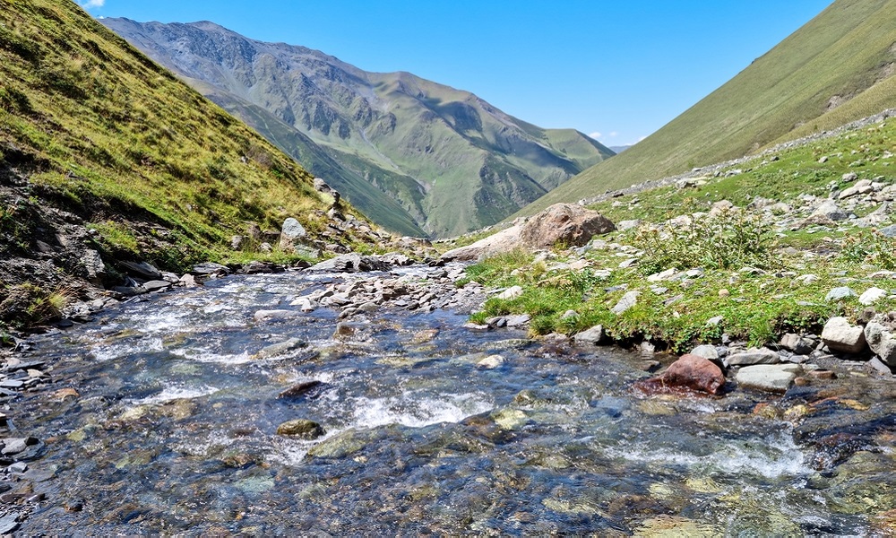
Complexity: Average
The path from jute to Roshka is suitable for not the first time on hikes. In fact, this is an advanced tracking to the Abuladuric lakes, only now you have to go up to the Pass of Chauha by 3,300 meters and only then go down to the destination. The route involves an overnight stay, so good preparation and the guide are required. The slopes of the mountains in many areas of the path consist of sharp shale, so the presence of strong and comfortable boots is a prerequisite for this trip.
The start originates in the village of Jute, where you can only get on foot or by all -wheel drive car from the village of SLU. Where, in turn, minibuses from Tbilisi or Kazbegi go. The valley along which the path will run is truly fabulous: in the vicinity, horses are in peace in peace, mountain streams run along the terry hills, and sharp teeth of the rocks dig into the sky. The pass opens a view of the endless ridges of peaks, which in good weather are as if shrouded in bluish haze and resemble watercolor. The descent is quite steep, so gain patience. As a reward below you will be expected by the landscapes of Abulaur lakes, which somewhat reminiscent of personnel from the film “The Lord of the Rings”. Do not forget to charge smartphones and take a powerbank with you – you will want to take pictures a lot! After a leisurely breakfast, you can go on the road – by dinner you will be in Roshka, from where you can leave by car in Tbilisi.
Where to stop
In jute you can linger and stay among the mountain serenity longer. Here are some good places:
Hotel Shibi (rating 9.1 out of 10) – from 2,650 rubles* per night in a double room;
Fifth Season (rating 8.9 out of 10) – from 6,100 rubles* per night in a double room;
JUTA GUEST HOUSE (rating 7.7 out of 10) – from 4,850 rubles* per night in a double room.
Messenia – Ushguli
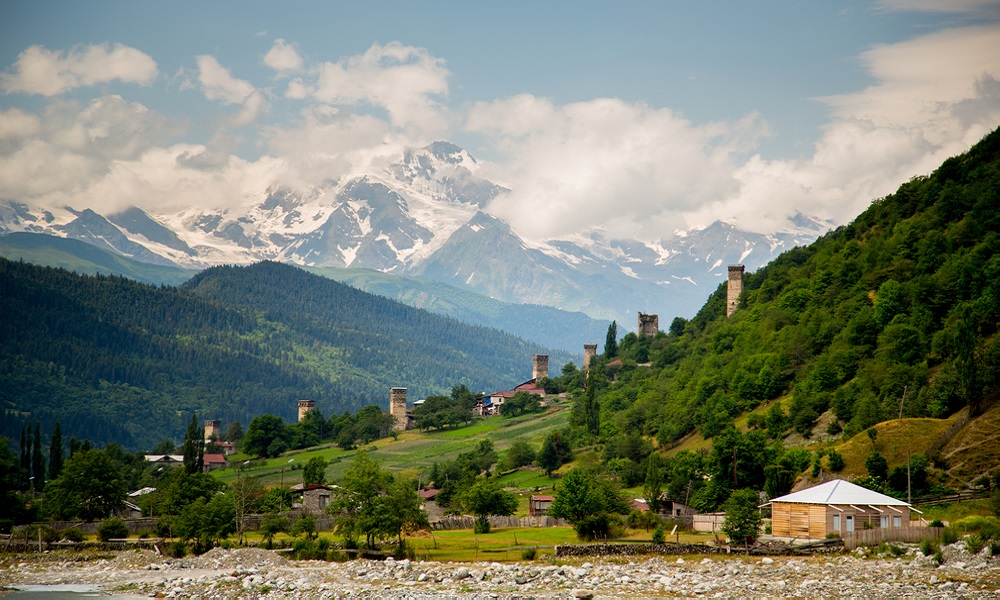
Complexity: Light/average
The completely outlandish “other” Georgia is located in the region of Svaneti, which is located in the north-west of the country. On the trip should be laid 7-10 days. In a multi -day campaign, it will be possible to get acquainted with the life of Svan, visit the highestor settlement in Europe – Ushguli, enjoy the views of rivers, glaciers and mountain meadows. The track is well marked on the ground, therefore, if you are confident in your abilities and have extensive experience in mountain campaigns, you can correctly calculate how much provisions you need to take with you on the road, and are ready to plan the route – you can go on your own (having previously set Maps.me). Or still use the services of guides.
To get to the Mestia from Tbilisi, you will have to drive almost the whole country – the road will take about 470 km. Therefore, as an option, you can fly immediately in Kutaisi, which is twice as close to the start point. The road from the airport to the Mestia will take 4-5 hours by car. The route itself begins from the Ethnographic Museum of Mestia on the right bank of the Tsaneri River and goes east to the Mulakh community. Further, the path passes through the gorge of Tsaneri, the village of Adishi, the gorges of Adishi and Halda, the Halde glacier, the Chhunder pass and descends to the highland settlement of the Ushguli along the Inguri River. Perhaps one of the most vivid impressions that are waiting for you is a panorama on a huge tongue of a glacier that slides into a valley, unusual Svan towers included in the list of UNESCO World Heritage, pink lanterns of wildflowers, worried in the wind among the huge wall of ice and mountains of Shhara.
Where to stop
After a multi -day route, it is usually the most desirable: hot shower, white stharged sheets, a bottle of cold lemonade and a leisurely dinner for a cozy terrace. All this can be found in the small city of Metia, where we recommend that we return to gain strength and relax. You can stop at one of the hotels:
Guesthouse Data (rating 9.7 out of 10) – from 1,550 rubles* per night in a double room;
Hotel Posta (rating 8.4 out of 10) – from 2,200 rubles* per night in a double room;
Hotel Svaneti (rating 7.6 out of 10) – from 10 140 rubles* per night in a double room.
*Prices are provided in mid -September and valid at the time of publication.
To search for cheap hotels around the world, use OneTwotrip.