
Armenia was created for hiking. The variety of landscapes and the rich historical heritage of the country have an interesting one -day campaign. In a few hours, you can conquer the top, take a walk through the forest, visit the ancient monastery. Or admire the picturesque gorge and relax on the shores of the mountain lake. Our author Maxim Dinishamov chose the most attractive options for you that do not require special training.
How to get
Direct flights fly from Russia to Armenia, for example, to Yerevan or Gyumri. The average cost of a one -way ticket is 8,000 rubles*.
It is most convenient to get to locations by car, but you can also by taxi or public transport. We will tell you more details below.
Waterfall Thrsch
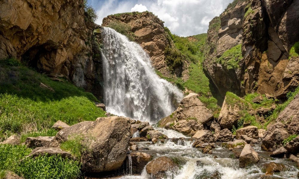
This is the highest waterfall in Armenia, its height is 23 m. The road here runs through the valley of the Chichkhan River, surrounded by small mountains. The name of the waterfall is translated as “jumping”: once local residents noticed how trout living in the river during spawning floats against the current and jumps out of the water. Since 2011, the territory around the waterfall has been declared specially protected.
How to get: The route begins from the village of Sarapat. You can get to it from the capital in your own car in about three hours. It is more difficult with public transport – there are options to get by a bus to a spitak or by train to Gyumri, and from there to order a taxi to the village. You can also use the trains of Yerevan – Batumi or Yerevan – Tbilisi, go down in the village of Kalttychi and order a taxi from there. The route itself runs along the Chichkhan River.
Complexity: A light route is suitable for beginners.
Experience: 7.1 km.
Season: The path runs through a crossed area, so it is better to choose the dry season. The least pleasant periods for the campaign are winter and the beginning of spring.
Mount Atis
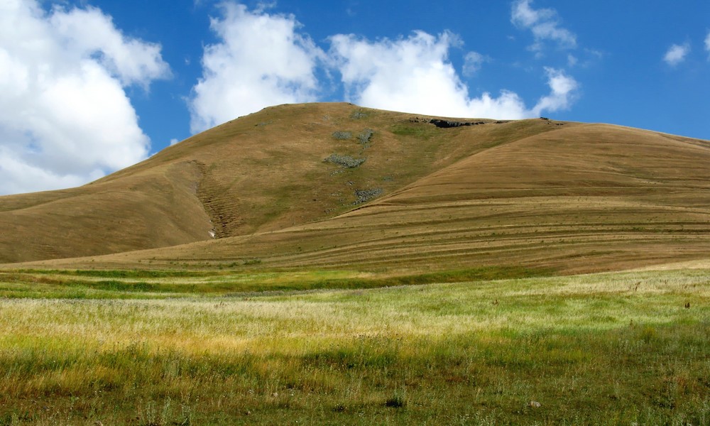
Plus this mountain is a close location to the capital. It is located 20 km from Yerevan and is part of the Gegham ridge formed in the distant past of volcanic activity. The top is bare, a convenient path leads to it, so it’s hard to get lost. On the season and on weekends, small groups regularly climb on an atis, and you can join one of them in order to certainly find the way. Beautiful views of Ararat and Aragats open from the mountain.
How to get: The foot of the mountain has two settlements – Atis and Kaputan. It is not too convenient to get to them by public transport, it is better to rent a car. But if you are not scared by old Gazelle, then ahead!
Complexity: Average. Be careful with the local fauna. Sometimes foxes and even wolves come across in the way. However, experienced tourists reassure: the inhabitants of the mountain do not touch anyone and behave friendly.
Experience: 11 km.
Season: In the summer it is hot and dry, snakes may come across. So it is better to choose a cool season. Especially good in spring: there is a lot of greenery and wildflowers on the mountain.
From the Goshavank monastery to Lake Gosh
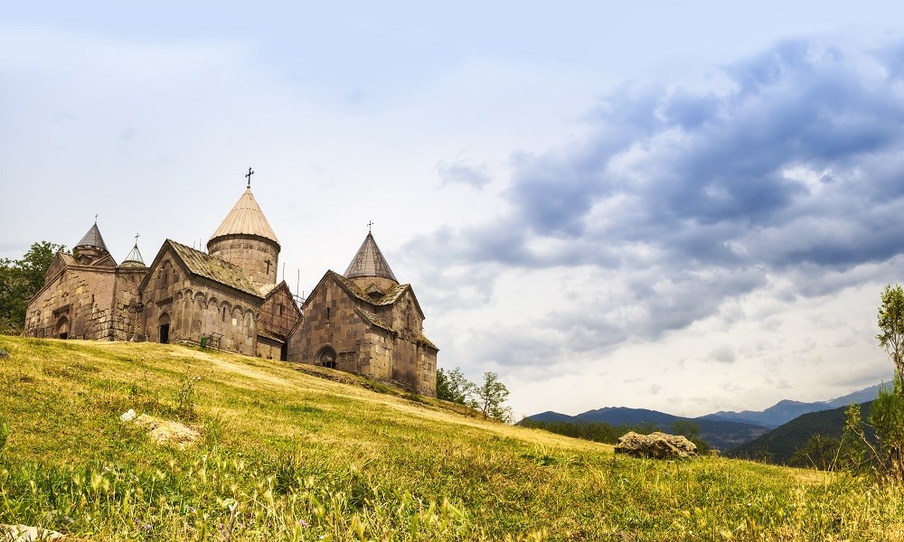
Forests of the Tavush region are one of the main natural wealth of Armenia. Near Diligan and Ijevana there are many popular places for relaxation. There are many routes available to beginners. One of these is the path from the Goshavank monastery to Lake Gosh. Small fields, streams, views of the mountains – there will be something to see. And the reward at the end of the route will be a mountain lake surrounded on all sides with a thick forest. There are two options for the campaign – you can go along the dirt road or walk along a marked path that begins a little south of the village of Gosh.
How to get: Get by car to the village of Gosh. You can also come to Dilizhan by public transport, and from there to order a taxi to the village. Minibuses regularly go from the capital to the stagecoat.
Complexity: Light. This route is ideal for leisurely acquaintance with nature.
Experience: 4-5 km.
Season: It is good here at any time of the year, but in winter there are fewer tourists who come to the lake in cars.
The southern peak of Aragats
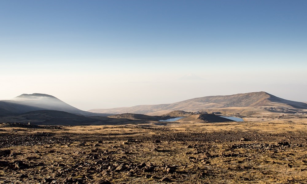
The highest mountain of Armenia – the extinct volcano Aragats – consists of four peaks: eastern, northern, western and southern. The first three are composed of rocks, climbing them requires additional preparation. But the southern peak is sexy, several convenient paths lead to it, along which tourists go in the summer period. The route begins by Lake Kari with a gradual set of 700 m of height. Travelers go through alpine meadows, which are replaced by rocky terrain. Here, even in August, you can get snow. Upon reaching the mark of 3,879 m – this is the height of the southern top – a view of the huge crater of the volcano opens.
How to get: Tourist minibuses are regularly sent to Kari Lake, information can be found with operators. It will also not be difficult to get by car on the car – the road is asphalt throughout.
Complexity: The route is complex. You need to be prepared for a long ascent and even a slight oxygen starvation. However, for a mountain of 4 km high, this is natural, not all such peaks are so accessible to an unprepared person.
Experience: 9–-10 km.
Season: Summer or early autumn, until the mountain is covered with snow. Even in May, the height of the snow cover here may exceed two meters, so in the cold season the ascent without special equipment is excluded.
From the Temple of Garni to the Azat reservoir
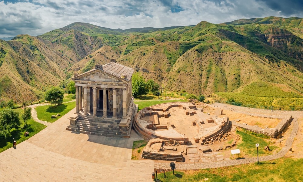
Garni is the famous pagan temple in Armenia. Next to him, the ruins of other interesting buildings are preserved, dating from the beginning of our era. At the complex, you can meet crowds of tourists all year round, but few people consider it as a starting point for the campaign. And in vain, because from Garni to the Azat reservoir surrounded by Martian landscapes, a convenient path leads. It runs along the Azat River, past the “Symphony of Stones” – symmetrical pillars from basalt, which were laid streams. The route there and back will take 7 hours, but if desired, it can be reduced by rising from the gorge to the village of Banavana – it is located in the middle of the route. From there you can call a taxi.
How to get: in Garni from the Yerevan bus station, Gai goes bus No. 284, the cost of the fare in one direction will be 250 drams (61 rubles). Even from the city market, Masiv walks a group bus, running daily from 10:00 to 20:30. The path by car will take 45 minutes, it begins from Ovannyan Avenue, which will lead to H3 highway – you will get to Garney. A taxi to the destination will cost approximately 3,400 drams (833 rubles).
Complexity: Average. The path is not difficult, but a walk there and back will take several hours.
Experience: 13 km.
Season: Summer or dry period of autumn and spring. In the offseason, the path can be blurred.
From Ahpat to Sanain
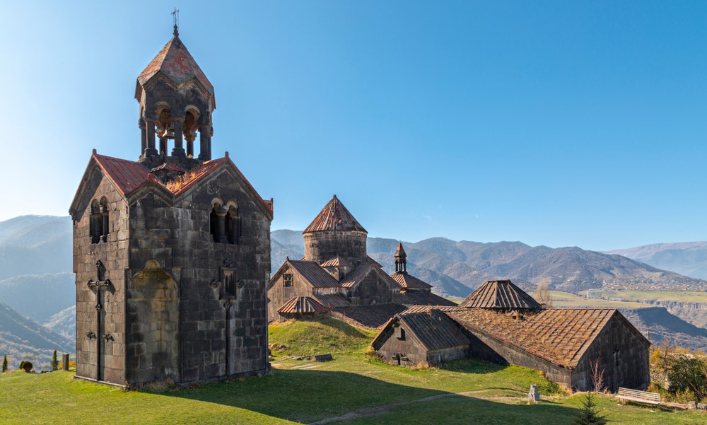
Monasteries Akhpat and Sanain – UNESCO World Heritage Objects, monuments of the Bagratides Management Autonomous Okrug in Armenia. Ancient temple complexes have an interesting internal structure and a rich history that began at the turn of the first and second millennia of our era. The route from one monastery to another runs through the villages of Sanain and Akner along the gorge of the Debit River. On the way, the ruins of the XIII century of the XIII century, also known as Aknaberd, will meet. Stone columns established by the team of the Armenian Association of Travelers will help to navigate along the path. There are many good species points along the way: the gorge on all sides is surrounded by mountains and small forests.
How to get: From the Central Yerevan bus station, minibuses go to Alaverdi – one in the morning and one day. The fare is 1,700 drams (416 rubles). If you go by public transport, it is better to stop for an overnight stay in the city. From it you can get to Sanain by taxi. In your own car, the road to Alaverdi from the capital will take three hours. You need to go to the M3 highway, go to Spitak. Then it is necessary to turn on the M6 highway towards Vanadzor – this road will lead to Alaverdi. The cost of a taxi to the destination starts from 18,000 drams (4,414 rubles).
Complexity: Average. A walk will take four hours, along the way there will be small changes in heights.
Experience: 8.5 km.
Season: At any time of the year, but most beautiful in the fall – the mountains are painted in bright colors, low clouds and fogs are creeping along the edges of the gorge.
Monastery of Marmashen and the surroundings
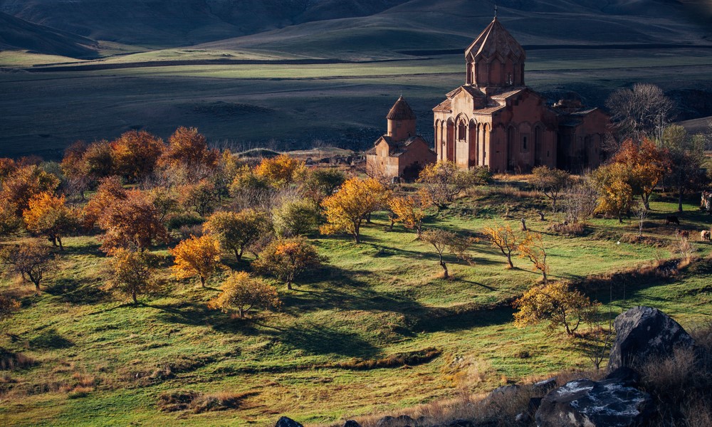
If you stayed in Gyumri, you can visit the monastery complex of Marmashen, located 15 minutes from the city. The place in which it was built was populated and was important even before Christianity arrived in Armenia. There are plenty of evidence of this: in the vicinity of the monastery, archaeologists found artifacts dating from the third millennium BC, a stone with cuneiform painting and the remains of the fortress of the state of Urartu were preserved here. Marmashen himself was the summer residence of the Bagratids, who in a hot period moved here from the capital of Ani located south of the capital. Since then, only two churches of the complex have survived.
Thanks to a two -hour walk, you can cover several points that give a good idea of this place and its history. Start with the old cemetery located north of the monastery. Here, the ruins of a small church, have graves whose age has several centuries. From here opens a beautiful view of the aragats and the gorge of the Akhuryan River. After inspecting the monastery, you can go down to the shore and reach the old hydroelectric power station in the south along it. The dam has two options for continuing the route: go east and go up to a stone with cuneiform painting and to the remnants of an ancient fortress or go across the river and reach the Asti waterfall in the north. Since all places are located close to each other, you can have time to combine both options.
How to get: From Gyumri to the monastery, Marmashen is more convenient to get by taxi for 1,500 drams (367 rubles). If you travel by personal car, move towards the village of Vagramerd, located west of the city. In this settlement, the main road will go to the right, you will see a pointer to the monastery to the left.
Complexity: Light. The walk is suitable for those who want to be in nature, but are not ready for many hours of campaigns.
Experience: 2-3 km.
Season: You can explore the monastery and its surroundings at any time of the year. But it’s easier to walk along the local paths in the dry period.